Sunday, August 31, 2014

Run #10: Center for Translational Research, Center for Turbulence Research, Children's Center of the Stanford Community, Clinic (Boswell), Clock Tower, Clubhouse, Cordura Hall, Cogen Facility

Phew, this run was tiring.

We always try to go on a long run on the weekend, with the goal of reaching seven miles.  We actually ended up running 7.8 (rounded down, Ira).

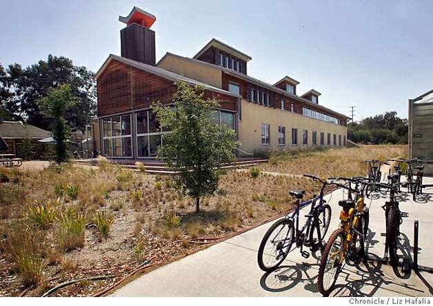
Our first stop is the Center for Translational Research, which is really far away on Welch Road.  It comes close to being the farthest place on the entire map.  Mo and Jake were with us today, and I think they were impressed that we took our shortcut through the hospital.  Along the way, we passed by the door to the Stanford Clinic.  This excited me; it was the third place to visit today, and I was nervous that wouldn't be able to find some random building attached to the hospital. The Center for Translational Research looked pretty ordinary from the outside, although I'm sure they're doing good work there.


I got us a bit lost trying to take a shortcut through the Children's Hospital – I swear there was new construction zones from the last time we were here – but we eventually wove our way back through the Quad to the Center for Turbulence Research (CTR).  We would go through the Quad about four times on this run, and the CTR was right next to the mythical building 590 that bamboozled us a week ago.

Next we ran through the Business School and around Maples Pavilion to the Children's Center of the Stanford Community (CCSC).  It is tucked in behind the softball field, and Ira used to work there.  We've run by it a few times before, and it is kind of cool that there's a preschool right by all the athletic fields.  It looked like they were setting up for a field hockey game as we ran by.  I wonder who they are playing.  I must admit I don't know much about Stanford's field hockey team.

When I told Ira and Jake that our next stop was the Clinic (Boswell),  they both groaned.  We did a 180 and ran back to the clinic door we had seen earlier.  At least we knew where we were going.

Then, it was back to the Clock Tower.  We certainly knew where it was (although I led us on another sort of wrong turn trying to avoid taking the exact same route we did before), but we ran all around it looking for a sign that said "Clock Tower".  There is no such sign, but I guess that it is a tower with a clock will have to be sufficient.  There is some good Clock Tower information on Wikipedia.


Jake and Mo decided to call it a day and head home at this point, since we'd already run about six miles, but we convinced them to check off one more building: the Clubhouse, which is part of Old Union.  It was just a few hundred yards away, and houses various student groups.  Jake and Mo then headed back to Wilbur Field.

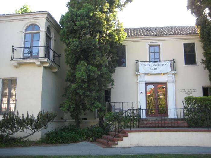
Ira and KMo, on the other hand, headed down Panama Street to Cordura Hall (CSLI).  Did you know that CSLI stands for the Center for the Study of Learning and Information?  Just kidding, the "L" actually stands for Language, so it is the Center for the Study of Language and Information.  Otherwise, studying learning and information seems to pretty much sum up everything that should be happening at at university.  Cordura Hall is a nice building, see?


At this point, we were already over our 7 mile goal, but we basically had to run right past the Cogen Facility to get back, so we checked that one off as well.  It's the "power plant" that provides electricity and heat to the whole campus, and is getting replaced by that newer crazy one out by the golf course.  We couldn't actually find a door or a sign, but we know we found it.

And, yeah, we ran way to fast on our final mile.  It hurt.

Total: 7.8 miles (actually 7.89, but I always round down, just to annoy Ira) for a grand total of 50.3 miles.  


Saturday, August 30, 2014

Run #9: Center for Advanced Studies in the Behavioral Sciences, Center for Clinical Sciences Research (CCSR), Center for Educational Research at Stanford (CERAS)

Only three buildings today, and, yes, I'm a day late again, so really it was yesterday.

This whole crazy adventure began because we felt like we were doing the same routes over and over again, so we figured going to obscure buildings would solve that problem.  It is sort of better, but we're finding we're running along the same streets and paths.  It seems like a lot of the time we're going from "this side" to "that side", and there are only so many ways to get there.  We seem to run down Santa Teresa almost every time, or at least it feels like that.

So, today we started off with another run up the hill by the golf course.  To get there, we avoided Santa Teresa and ran straight through the middle of a dry Lake Lagunita.  It may not have been a well thought-out plan, as Ira sort of tripped on the uneven ground at the beginning and hurt himself a bit, so we had to pause for a stretching break.

Our weird route did take us right by this object, which we had seen from afar on our previous run.
Does anyone have any idea what this is?  It looks like some sort of "cage", but we can't figure out what kind of animal you could keep inside.  Birds or small mammals could get through the gaps in the mesh, and a larger animal could either gnaw through the mesh or scurry under it.  And we couldn't figure out why a person would be in there, since it doesn't provide any shade or anything.  Weird.

Eventually, we got to our first stop, the Center for Advanced Studies in the Behavioral Sciences.  It is way at the top of the golf course hill, and we'd actually been there before when we were confused  by the location of our first stop on this whole adventure: 30 Alta Road.  (Oh, the good old days, when we really didn't know what we were doing.)  As always, a pretty view, and we won't be back up this hill for a while.

Our next stop was the Center for Clinical Sciences Research (CCSR), which is in the Med School.  I got mixed up and was looking for the building on the left side of the path, but it is actually on the right, so we had to stop and check my phone.  (My bad!)  I think this would probably get my vote for the coolest looking building on campus anywhere, especially if there was a "New Architecture" category, since it is tough to beat the a classic like Memorial Church.  I always think they should film some science fiction movie here, since it looks so futuristic.  Lots of glass and cool angles.  I'm such a fan I'm posting two pictures.

Our last location was the Center for Educational Research at Stanford (CERAS).  This is really close to Wilbur Field, and we almost thought about saving it for our next run.  However, we felt silly about having a run with only two stops, so we checked it off the list.  Ira's office is in this building, and we actually started here because I left my backpack in his office.  Not much to say, and Ira spends so much time in this building that I'll leave any historical anecdotes for the peanut gallery.

Oh, and we had some good conversations on the run, including KMo's trip to the Genius Bar to fix his MacBook Air, the fact that Stanford is favored by way to many points over UC Davis, and high school students mis-using twitter.  And a few other things I can't remember now.

Distance: 4.1 miles (note to mathematicians out there - I will always be rounding down, although I'm not sure why; maybe I don't trust the accuracy of Ira's pedometer).  We're at 42.5 miles total.


Wednesday, August 27, 2014

Run #8: Carnegie Foundation, Carnegie Institute, Cedar Hall

Jake and Mo came running with us again today.  The conversation is always interesting, ranging from Vince Wilfork eating a chicken sandwich with bones, my new favorite movie "Tim's Vermeer", what it is like to work at any of the Carnegie Buildings on campus, and probably a few other things I forgot.

On the way to our first destination, we ran by Lake Lagunita, and saw a guy practicing juggling clubs while balancing on a rope tied between two trees.  Almost simultaneously, we noticed some object with netting right in the middle of the dry lake bed.  We couldn't figure out what it was: trampoline, soccer or lacrosse goal, or some enclosure for birds or butterflies.  It's not on the map, though, so we kept going.

We eventually ended up at the Carnegie Foundation.  Go up by the golf course and keep going up the hill to the very last building.  It has to do with teaching, so Ira told us all about it, and Mo found this little pool/pond and took a quick swim to cool off.  It's a very pretty building with a nice view.

Andrew Carnegie apparently had so much money that his wealth funds two organizations at Stanford.  The next one is down the hill and is called the Carnegie Institute.  It is tucked away, and apparently has to do with studying plant growth, and is next to another cool corn field.  It is an interesting building; from far away it looks like one of those run down Stanford buildings from another era that probably should be closed down soon, but when we got up to the door there were people inside working and it looked pretty nice.

OK, I just did some googling, and I think we've got a problem.  There is, apparently, another Carnegie Institution building.  It is right next door, and looks all high-tech and environmental.
This is the building we saw on the other side of the chain link fence.  I'll have to do some more research about the difference.  We definitely got to a Carnegie Institute building of some kind (we saw the sign and touched the door, honestly), but we might have to go to this one too.  This map needs some serious work.

Lastly, we went by Cedar Hall.  It is a nondescript old building right next to the power plant.  I'd be shocked if it wasn't next on the list to be knocked down to make way for the improvements to the whole engineering side of campus.  It was a pretty run back through the quad, though.  Jake was really impressed with the sight lines.

Distance: 3.4 miles (I always round to the nearest tenth, and it was actually 3.49 miles, even though clearly Ira didn't start his pedometer for at least a few hundredths at the top of the hill by the Carnegie Foundation).  Total distance is 38.4 miles, according to my tally.

Tuesday, August 26, 2014

Run #7: Bolivar House, Bookstore, Braun Music Center, Brick Barn, Cantor Arts Center

We've made it to the C's.  No more B's!

Yesterday we started at the Bolivar House, which is, I'm pretty sure, the closest building to our Wilbur Field starting point.  Ira's pedometer watch gismo makes him walk about five minutes before it is ready to track our run, and we actually walked beyond this house and had to run back.  We were at our destination after 0.06 miles, which I think will be the record.  It's a pretty house, though.

Next we went to the Bookstore, which is pretty close by.  We obviously knew this location well, but we noted that it has a number on it.  We had a brief discussion of what street it is actually on, and what would happen if you tried to mail something to "Bookstore, Stanford, Ca".  It would probably get there, wouldn't it?  Weird to think that most buildings have both a name and an address.  Maybe that's why the post office was always so slow.

Nearby is the Braun Music Center, which we actually ran through to get to the Bookstore.  I've probably run by this building hundreds of times, but I can't remember if I've ever actually been inside.  That probably tells you a lot about my musical abilities.


At this point, we had probably run about half a mile.  Ira made a mistake last run by pointing out that we normally run our first mile much too slowly, so the pace on this run was pretty darn fast.  Four miles, with the slowest one around 8:12, I think, and the final fastest one around 7:00.  We had to cut out the in-depth, deep philosophical discussions we usually have.

Next was a run all the way across campus to the Brick Barn.  I'd never been there before, but I knew it was way out by the equestrian area near the golf course.  We'll be returning later for a few other buildings, most notably the pretty Red Barn.  We couldn't actually find a sign that said "Brick Barn", but it was a barn made of bricks on the correct spot, so we're taking credit for it.

At this point I thought we should head back to Wilbur Field, but Ira calculated that it would make the run distance less than three miles, so we headed over to the Cantor Arts Center.  The highlight along the way was the fountain by the Gates building actually flowing with water, since most of the fountains are inactive due to the drought.  This museum is pretty great, and it is free.  A great way to spend a rainy day, if we ever have a rainy day again due to the drought.


Overall, a pretty good run that ended up longer and faster than I expected.  I was definitely tired.

Distance: 4.2 miles (total distance 35.0 miles)

Sunday, August 24, 2014

Run #6: Blake Wilbur Clinic, Buildings 1–370, Buildings 500–610, Bleeker

It was a weird run today, because of all these numbered buildings.  Very enjoyable, but weird.

We started off with a long trek to the Blake Wilbur Clinic, which is way on the other side of the hospital and is one of the only buildings not under construction.  It is sort of an island in a sea of construction; we saw it from afar, but we couldn't quite figure out how to get there.  Once we touched the door (we've gotten in the habit of touching every single building), we got a bit cute, and tried to weave our way back through the hospital construction maze.  We were totally unsuccessful, and took a few terrible wild-goose-chase-like detours: we ended up in a courtyard we'd never seen before, and then we ran down these steps which looked like they might lead to a secret path out.  Nope.  I bet the hospital employees with windows facing out were wondering why two idiots were running down a path that led to a chain link fence dead end.


Eventually we made our way out (surprisingly, we ended up exiting by the Children's Hospital), and ran over to the main quad.  The map says Building 1 – 370 (see Main Quad).  I decided that this meant we had to visit every numbered building that does not have a name, because the named buildings will appear later on the map, so we'll visit them later.  For example, the Psychology department is building 420, but it is called "Jordan".  The "History Corner" is building 200.  The numbering system for the quad makes some sense: we ran one loop around the inside, moved to the "middle", and then around the outside of the back.  This spiral hit every building, and we touched every door.  The highlight was the Anthropology department: I noticed that it seemed to be the only building with two buildings, and Ira passed along the rumor that there are sort of two ways of thinking about anthropology, and it is divisive enough that they have to be in different buildings.  I hope that's true.


The numerical order of the quad was contrasted with the ridiculous layout of Buildings 500 – 610, which are behind the quad and up a little rise.  They are mostly engineering buildings, but we got totally bamboozled here, and had to constantly check the map on my phone.  So many questions:

  • We were never actually sure we found building 520, since it was surrounded by chain link construction fence.
  • The buildings normally go up by ten in the quad (10, 20, 30, etc), and that pattern is more or less repeated here, except there is no building 510 (it goes 500, 520, 530), and, for some inexplicable reason, there is a building 524, the only number that isn't a multiple of ten.  What happened to building 510?  And why the heck is it 524?  If you felt compelled to add a building between 520 and 530, wouldn't you pick 525 instead?  What are these engineers doing?
  • We then got totally mixed up by the mystery building 590.  First, there is no building 580 or 600, which is weird.  We really couldn't find building 590 at all.  We stopped and looked at my map, and it seemed like it was part of Old Union, which is weird since all the other buildings are engineering academic spaces, and this looked like it was "The Nitery", which hosts some student groups.  We ran around it, and it never says "building 590" anywhere.  Not once.  We checked.  Then, we found a construction sign that had a map of what this region will look like when the construction is done, and it said "Building 590 (The Nittery)".  Yes, it is spelled correctly, but I'm not sure how these maps are supposed to help. If you are looking for "The Nitery", it isn't on the map.  If you're looking for "Building 590", the building doesn't have a sign identifying it as such.  Who do we complain to?  I wonder which building has the office of the person responsible for this map?

At this point, we were at five miles, due to getting lost at the hospital, weaving around the quad, and looking for building 590.  So, we only hit one more building: Bleeker.  It is one of those weird buildings by Searsville Road that look sketchy and abandoned.  Not very interesting, but we really tried to pick up the pace, especially on the way back.  Our last mile was at a pace of 7:04, according to Ira's pedometer.  That's pretty fast for us.

Total: 7.0 miles (30.8 since we started)

Saturday, August 23, 2014

Run #5: Bing Concert Hall, Bing Wing, Biology Greenhouses, Birch, Black Community Services Center

I'm again a day late on this blog post.  We ran yesterday, and we were joined by two special guests: our friend Jake, and his dog Mo.  We were delayed a bit at the beginning of the run, as, um, Mo had some business to attend to.

Our first building was the Bing Concert Hall.  Because I feel compelled to point out the ridiculousness of this alphabetical adventure, let me once more remind everyone that this should have come before the Bing Nursery School, not after it.  The Bing Concert Hall is a relatively new building, and I actually haven't yet been inside it, but it sure looks pretty from the pictures.

Next we all ran to Green Library, where the wing closer to the Main Quad is called the Bing Wing.  Not really much to report here, except that it wasn't too far away and we had trouble finding any sign that said "Bing".  Jake eventually found a plaque.

If possible, we always try to find the sign that identifies each building.  Usually we touch a door or a railing or something.  A few people have suggested that we go inside each building, or take a selfie by each building.  Ira and I discussed this early on and dismissed it.  Many of the buildings are closed when we go running, and the whole point is to get some exercise, and taking a bunch of pictures would really slow us down.  You'll have to take our word for it that we went everywhere.

We then ran across campus to the Biology Greenhouses.  They are on the other side of Campus Drive, near the new power plant.  Or, at least they are supposed to be, according to the map.  The whole area is surrounded by chain link fence, so we had to run around a lot to figure out our way inside.  We found the greenhouses, about ten of them, surrounded by a pretty legitimate looking field of corn, although the only sign we could find called it the "Plant Research Center" or something like that.  No mention of "Biology."  According to the map, though, we were certainly in the right spot.  That'll do, little pig.

Nearby was the Birch module, a series of portables all named after trees.  This is our second stop here, following our visit to Acacia about a week ago.  The sign on Birch mentioned something about IT support training.

Our final stop was the Black Community Services Center.  We had a ridiculous conversation on the way there about it's location.  Ira claimed it was "behind Tresidder".  I said that it was near Tresidder, but that it was far enough away that I wouldn't describe the location using the word "behind".  Ira contended that, while, yes, it wasn't "behind" Tresidder like a dumpster that is right behind it, it was "behind" it in the same way Lake Lagunita is behind it.  I'd like to say that we then deviated into some socio-anthropological discussion about relativism as it related to one's worldview, but we were there already.  It's a nice building, see?


While we were technically done, we did do one more stop for posterity.  Meyer Library, located in the center of campus, closed for good a few hours earlier, so we had to run by it and pay some homage to a place where all three of us spent a lot of time studying.  It never was the prettiest building on campus, but a lot of book learnin' happened there.  We'll miss you.


Total: 3.6 miles (23.8 since we started)

Wednesday, August 20, 2014

Run #4: Beckman Center, Bing Nursery School

Even though this post is going up on Wednesday, we actually ran on Tuesday.  We just went to two places, because they were far apart and we were tired.

First, the Beckman Center, which is at the medical school, right next to the hospital. We had to run all the way around the building to see the sign to be sure we had the correct building, but at least there was a cute dog. According to the website, the Beckman center was"founded on the principle that innovation transcends traditional departmental boundaries". Huzzah!

Next we ran all the way across campus to the Bing Nursery School.  We both were pretty familiar with where this was, as I took a great class there as a Stanford student ("Observation of Children") and Ira is Mr. Education Guru, so he knows it well too.

We probably should have gone to one more building (the Bing Concert Hall is next on our list, even though astute readers will note that it comes before "Bing Nursery School" alphabetically), but we were tired and that would have made our run too long, so we ran pretty darn fast the last half mile back to Wilbur Field.  It was sub-7 minute pace, for those of you keeping score at home.

Stats: 3.2 miles, bringing us to 20.2 miles total

Sunday, August 17, 2014

Run #3: Arrillaga Alumni, Art Gallery, Artist's Studio, Automotive Innovation, Bambi, Barnum Center, Barnes, Bechtel International Center

On Sundays we usually go on a longer run.  Lately we've been aiming for about seven miles, so we were able to check eight places off our list today.  It seemed like the shortest long run we've had, since we always had a goal.  I think this silly plan of ours is working: the run today seemed mentally easier.

Before I get too far, though, I have to mention the weird thing with this run.  We realized that the map actually doesn't list the buildings in correct alphabetical order.  Notice that the Barnum Center is listed before Barnes.
We realized this about halfway through our run, and then we thought must have been wrong.  But, yes, we were so tired we forgot how alphabetical order works.  (I just noticed we're going to have a similar problem in a few days: Bing Concert Hall should really come before Bing Nursery School.)

So, at about mile 4 today, we decided that we would follow "map-abetical order".  That is, the map is the final word.  If it is wrong on the map, perhaps the almighty map-maker knows something we don't, so we're following that order no matter what.

OK, on to today's run: We first went to the Arrillaga Alumni Center, a huge building that didn't exist when we were students, but no doubt has helped Stanford's endowment.  I guess I'm amazed that it is the only building named "Arrillaga" to make the list.

Next was a short stretch to the Art Gallery, which is right next to the History Corner in the Quad.  It was closed for construction, but we made a mental note to go back when it was open some time.  I can't remember the last time I was there.

Then we headed up on the longest stretch of our journey to the Artist's Studio, which is up the hill by the golf course across Junipero Serra.  I'm noticing that the quality control on this map is quite poor: shouldn't it be "Artists' Studio"?  I'm assuming this building is shared by more than one artist.  Or, is there one official Stanford artist?  If so, we have to meet this person who important enough to deserve an entire building.  Anyways, it was behind barbed wire, so we couldn't get very close, although, as always, the view by the golf course in the foothills was awesome.

Next was the Automotive Innovation Facility, which was surrounded by construction.  It had some cool garages with big glass windows.  I found a cool picture from the inside, although it had a lot more cars inside when we saw it.

We were so excited for the next stop: Bambi.  Despite the cool name, it is just a portable next to Roble Field.  It looks like it has been there for a while.  I wonder why it is called Bambi?  

Following "map-abetical order", our next stop was the Barnum Center, right next to the clock tower.  Since it is affiliated with the School of Education, Ira knew exactly where it was, and he said he goes there about once a week.  I still thought the building was the Career Center, which it was when I was a student. 

Sadly, our next place was a building called Barnes, which was in the exact opposite direction.  It is basically next to the Automative Innovation Center, so we had to pretty much turn around and head back in the opposite direction.  We have absolutely no idea what this building was.  There really wasn't a sign, and it looked like the kind of abandoned place Jack Bauer would find bad guys.  It would be a great place for paintball.  Or hiding from society.  One of the signs said "Sensitive Material Inside."  If Stanford is building a death ray, this is where it is happening.

Our last stop was the beautiful Bechtel International Center.  It's right by Tresidder, on the way home.  We were really tired by now, so we didn't stop and linger.


Topics of conversation on today's run included the international student party last night that was too loud and kept Ira up until 3:30, the saga of KMo replacing the thermocouple in his hot water heater, the "30 for 30" documentary on Bo Jackson, and Ira's big plan involving teachers.

Total: 7.0 miles (17.0 total)


Friday, August 15, 2014

Run #2: Advanced Medicine Center, Anatomy, Arboretum Children's Center, Arguello

The theme of this run was "construction".  Our first building was the Advanced Medicine Center, also known as the Cancer Center.  I should have known where this was, because I've taken my friend Ken there a few times, but I didn't recognize the name.  We found it eventually, although we got totally confused by the fact that the entire hospital area is under construction, and so every path we seemed to take ended up in a temporary fence or barricade.


On the way out, we took a wrong detour and got stuck in a valet parking lot, but then found a sneaky path to get through the hospital without going all the way around it.  That might come in handy later on.

Our next stop was a weird one: our map says Anatomy, but that's not listed on the map anywhere.  We did some googling before our run, and learned that the old Anatomy building was torn down, and is being replace with a new building.  In a weird twist, that building will be called the McMurtry Building, and I've met Deedee and Burt McMurtry.  They couldn't be nicer people.  Anyways,  Ira and I ran by the construction site of the McMurtry Building, formerly the Anatomy building. 

We then had a long run down Palm Drive to the Arboretum Children's Center.  The map (which we're beginning to question) says "Currently closed", although the doors were open when we got there.  Some people were carrying out boxes, though, so maybe we were seeing it in its final days.

On the way back, we were at a crosswalk and someone was turning without looking for pedestrians.  Ira said "Look out" to me, but another man heard him and started to walk, perhaps thinking that "look out" meant "start walking".  He almost got hit.  

As an aside, it has been a pretty common occurrence that people driving have not seen us.  Yes, we're often coming down weird paths from the wrong direction, but please look where you're going.

Our last stop was Arguello, 425, 427, & 429 (Encina Modular A, B, C).  Ira picked up the pace this last mile and went way too fast, but these are near Crothers and Toyon.  In the grand finale for our construction theme, these weren't there at all.  

So, the final score: 4 buildings (2 not there at all due to construction, 1 difficult to get to since it was surrounded by construction, 1 closing for some reason).

Total distance: 4.8 miles (10.0 miles total).

Thursday, August 14, 2014

Run #1: 30 Alta Drive, Acacia, Acorn House

For some reason, the first building listed on the map is 30 Alta Road.  We're not quite sure why.  It is the only building that begins with a number in the entire section, so I guess numbers come before letters.  Alta certainly doesn't come before Acacia.


Alta Drive is on the other side of Junipero Serra, if you go up the hill from the driving range.  It was a pretty long journey for first building, but neither of us had been up their in a long time.  You get some great views of campus and the foothills, and we talked about going this way to sneak onto the dish for some future run.  It was very calm and beautiful: we saw a deer and a huge jack rabbit hopping through a field.

30 Alta Road is a research building tucked into some oaks.  We weren't sure that it was the correct building, so we actually ran up the hill a bit before pausing to look at the map to make sure we had found the right building.

We're a little bit fuzzy on our rules of what "visiting" a building means.  We're not going to go inside each building, but we're going to try to see the plaque that identifies the building, and maybe touch a door or railing.  We can't just see it from afar.

Next was Acacia, one of several "portable" buildings in a small cluster tucked right off campus near the power plant.  We'd run by them several times and never noticed them before.  The cluster has a tree theme, so we'll be making a few return visits to portables like Birch and Oak.

Along the way, we had this conversation:
Ira: "Why didn't we come up with this idea a long time ago?"
KMo: "Because it's stupid."
Ira: "Of course.  So why didn't we come up with it a long time ago?"

We decided to hit one last place: Acorn House is way out by the intersection of El Camino and Serra. It made the run way too long, but we got there.  It is a newer building, and looks like it houses some daycare or children's center.  I probably should have read the sign more carefully, but we were tired.

We then weaved back through Escondido Village, not really having any idea where we were going.  We did find a nice community garden, however.  I think we're going to see lots of things we'd never seen before.

Total distance: 5.2 miles (much further than we should have gone)

The Original Idea

Ira and KMo (that's me) go running quite a bit around the Stanford campus.  We usually meet at Wilbur Field and run about three or four miles.  On August 13, 2014, Ira decided that our runs were getting a bit predictable.  That's true; we tended to do variations of the same route.  We'd usually do the Campus Drive loop, some run up to the Dish, or just meander around the Mayfield faculty housing area.  Rarely would we go anywhere else.

So, Ira suggested we need some new plan, a wrinkle to keep our runs fresh and interesting.  An idea popped into my head.

We would run to every building on campus in alphabetical order.

After a bit of searching, I pulled up a campus map on my iPhone.

This map is going to be our guide for the next several weeks and months.  On the second page of the map, there are some long lists of the places on the huge Stanford campus.  I counted 209 places in the "Building" section, although it's possible that I miscounted.

Here are the rules: Ira and I are going to go on runs, visiting all 209 buildings listed on the map, in alphabetical order.  We'll always run together, and start and end at Wilbur Field.  We won't have a set number of buildings to visit each run, but we think that we'll probably average about three buildings to get to our usual distance of a few miles.

I'll be updating this blog with the story of our journey.